Davos is much more than a world stage for economic forums — it’s a spectacular destination for hikers in search of fresh air, panoramic views, and unspoiled alpine terrain. Nestled at 1,560 meters in the Swiss canton of Graubünden, it is one of Europe’s highest towns and offers a vast network of marked hiking routes for all experience levels.
From gentle lakeside paths to ridge walks that span valleys and peaks, here are ten handpicked trails that show off the best of hiking in Davos.
🏞️ 1. Lake Davos (Davosersee) Loop
⏱️ Duration: 1.5 hours
🧭 Difficulty: Easy
📍 Starting point: Davos Dorf
⛰️ Elevation gain: ~100 m
Description: A flat, scenic loop around the glacial Lake Davos with paved and gravel sections. Perfect for families and leisurely walkers. In summer, combine with a picnic or a swim at the beach area on the northern shore.
🌲 2. Sertig Valley Trail
⏱️ Duration: 3–4 hours (round trip)
🧭 Difficulty: Moderate
📍 Starting point: Clavadel or via bus to Sertig Sand
⛰️ Elevation gain: ~300 m
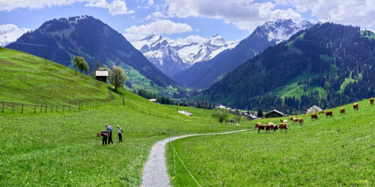
Description: This peaceful valley is lined with pine forests and traditional Walser farmhouses. Hike past waterfalls and grazing cattle before reaching the Sertig Dörfli, one of Davos’ most photogenic spots. Ideal for escaping crowds.
🌲 3. Turbach Valley Trail
⏱️ Duration: 3 hours (one way)
🧭 Difficulty: Moderate
📍 Starting point: Gstaad village
Description: Less frequented than other routes, this trail leads hikers through the quiet Turbach Valley. Expect shaded forest paths, charming alpine huts, and old wooden barns. The peaceful ambiance and sound of flowing water make this an ideal route for those seeking solitude.
🌾 4. Schatzalp–Strela Pass
⏱️ Duration: 4–5 hours
🧭 Difficulty: Moderate
📍 Starting point: Schatzalp funicular
⛰️ Elevation gain: ~600 m
Description: Begin at the historic Schatzalp Hotel and ascend to the Strela Pass for breathtaking views. This route combines alpine history with quiet trails and mountain charm. An alpine hut near the top offers refreshments..
🌿 5. Zügenschlucht Gorge Trail
⏱️ Duration: 2.5 hours
🧭 Difficulty: Moderate
📍 Starting point: Davos Monstein
⛰️ Elevation gain: ~350 m
Description: Follow the rushing Landwasser river through a dramatic gorge. The path includes old railway bridges, tunnels, and towering rock walls. A hidden gem and one of the most unique trails in the area.
🐑 6. Rinerhorn Panorama Trail
⏱️ Duration: 2 hours
🧭 Difficulty: Easy to moderate
📍 Starting point: Rinerhorn cable car station
⛰️ Elevation gain: ~250 m
Description: A ridge walk above tree line with views toward Filisur and the Albula Alps. Families love this trail for its wildlife sightings — from marmots to ibex — and its accessibility from town.
🏞️ 7. Flüela Pass to Jöriseen Lakes
⏱️ Duration: 5–6 hours (loop)
🧭 Difficulty: Challenging
📍 Starting point: Flüela Pass summit (accessible by car or PostBus)
⛰️ Elevation gain: ~750 m
Description: A stunning high-mountain circuit that passes multiple glacial lakes in various shades of turquoise. Rocky terrain, steep sections, and altitude make this a full-day adventure for experienced hikers.
🌲 8. Dischma Valley Trail
⏱️ Duration: 4–5 hours (one way)
🧭 Difficulty: Moderate
📍 Starting point: Davos Platz
⛰️ Elevation gain: ~500 m
Description: Follow a narrow valley between steep flanks toward the mountain hut at Dürrboden. A quiet trail perfect for hikers who want long, peaceful walks in nature. Possibility to stay overnight at the hut.
⛰️ 9. Pischa Ridge Trail
⏱️ Duration: 3 hours (loop)
🧭 Difficulty: Moderate
📍 Starting point: Pischa gondola top station
⛰️ Elevation gain: ~400 m
Description: Known for its wide, open plateaus and views of the Flüela range. This trail offers sun-soaked ridgelines and a sense of isolation. Great for trail runners and panoramic photography.
🌅 10. Sunrise Hike to Strelapass
⏱️ Duration: 2.5–3 hours
🧭 Difficulty: Moderate
📍 Starting point: Schatzalp or Höhenweg
⛰️ Elevation gain: ~500 m
Description: Start early to catch the first light over the Davos valley. This hike is all about atmosphere — stillness, morning mist, and mountain glow. Bring a thermos and enjoy breakfast with a view.
🧳 Tips for Hiking in Davos
🌦️ Weather: Check local forecasts before heading out. Conditions can shift rapidly in the high Alps.
🥾 Footwear: Even on well-marked trails, wear sturdy shoes with grip.
🗺️ Maps: Free trail maps available at the Davos Tourist Office or via the Swiss Mobile App.
🚡 Lifts and Buses: Use mountain cable cars and PostBuses to access remote starting points.
🧗 Guides: For alpine or glacier tours, certified mountain guides are available.
With its clean air, elevated setting, and wide range of trail options, Davos is a hiker’s dream come true. Whether you’re walking beside a glacier-fed stream or climbing to a sunrise peak, every trail here rewards with beauty and quiet. Take your time, breathe deeply, and let Davos show you a different side of the Alps.