Grindelwald, tucked into the Bernese Oberland, is a picture-perfect alpine village offering direct access to some of the most iconic hiking routes in the Swiss Alps. Towering peaks like the Eiger, Wetterhorn, and Schreckhorn provide a dramatic backdrop to well-marked trails ranging from serene lake loops to panoramic ridge walks. With the help of mountain railways and gondolas, even high-altitude adventures are within reach.
Here’s a handpicked selection of the best hikes in and around Grindelwald — including all the key information to help plan your trek.
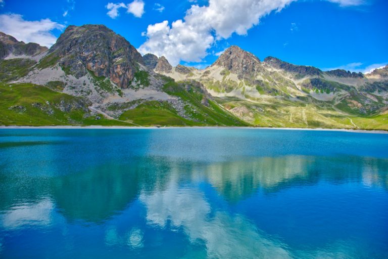
🏞️ 1. First to Bachalpsee
⏱️ Duration: 2 hours (round trip)
📏 Distance: ~6 km
🧭 Difficulty: Easy
⛰️ Elevation gain: ~200 m
📍 Starting point: First gondola station
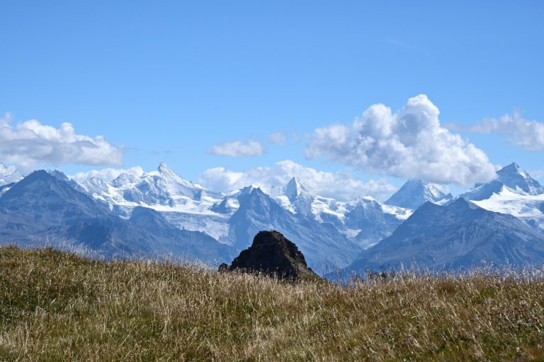
Description: One of the most famous hikes in the Jungfrau region. A scenic, gentle path leads to the crystal-clear Bachalpsee lake, with reflections of the Wetterhorn and Schreckhorn. Great for beginners and families. Sunrise and sunset here are particularly magical.
🏔️ 2. Eiger Trail
⏱️ Duration: 2.5–3 hours (one way)
📏 Distance: ~7 km
🧭 Difficulty: Moderate
⛰️ Elevation gain: ~250 m (mostly downhill)
📍 Starting point: Eigergletscher station (Jungfrau Railway)
Description: This legendary trail hugs the base of the north face of the Eiger. Packed with alpine history and incredible views, it descends toward Alpiglen and Grindelwald. Interpretive signs share stories of climbers and mountaineering feats along the route.
🌄 3. Faulhorn to Schynige Platte
⏱️ Duration: 5–6 hours
📏 Distance: ~15 km
🧭 Difficulty: Moderate to challenging
⛰️ Elevation gain: ~700 m
📍 Starting point: Faulhorn (accessible via First + hike)
Description: A ridge walk with nonstop panoramas over the Bernese Alps and turquoise lakes. Considered one of Switzerland’s most scenic long-distance trails. The historic Faulhorn hotel (one of the oldest mountain inns) makes a charming rest stop.
🌲 4. Grosse Scheidegg to First
⏱️ Duration: 2.5–3 hours
📏 Distance: ~7.5 km
🧭 Difficulty: Moderate
⛰️ Elevation gain: ~400 m
📍 Starting point: Grosse Scheidegg
Description: A quiet trail through alpine meadows and under dramatic cliffs, this hike offers tranquility with stellar views of the Wetterhorn. Reachable by PostBus from Grindelwald, this route is a great mid-day excursion before enjoying a late lunch at Berggasthaus First.
🐐 5. First–Faulhorn–Bachalpsee Loop
⏱️ Duration: 4.5–5 hours
📏 Distance: ~11 km
🧭 Difficulty: Moderate
⛰️ Elevation gain: ~600 m
📍 Starting point: First gondola station
Description: Combine three Grindelwald classics into one: climb to Faulhorn, descend to Bachalpsee, and return to First. Expect lush valleys, breathtaking ridgelines, and high-mountain air. Perfect for active day-hikers.
🏞️ 6. Panoramaweg Männlichen to Kleine Scheidegg
⏱️ Duration: 1.5–2 hours
📏 Distance: ~5 km
🧭 Difficulty: Easy
⛰️ Elevation gain: ~150 m
📍 Starting point: Männlichen lift station
Description: A relaxing ridge trail with views of the Eiger, Mönch, and Jungfrau trio. Great for casual walkers and photography lovers. Combine with lunch at Kleine Scheidegg and a train ride down to Grindelwald.
🌅 7. Wetterhorn Trail
⏱️ Duration: 3–4 hours (round trip)
📏 Distance: ~8 km
🧭 Difficulty: Moderate
⛰️ Elevation gain: ~500 m
📍 Starting point: Grosse Scheidegg
Description: A lesser-known hike with close-up views of the imposing Wetterhorn. Wildflowers, alpine streams, and fewer crowds make this a peaceful retreat. On sunny days, the cliffs of the Wetterhorn glow with golden light.
🌄 8. Pfingstegg to Bäregg Hut
⏱️ Duration: 2.5 hours (round trip)
📏 Distance: ~5 km
🧭 Difficulty: Moderate
⛰️ Elevation gain: ~300 m
📍 Starting point: Pfingstegg cable car station
Description: A stunning trail along the edge of the glacier gorge. Bäregg hut serves meals and offers views over the Lower Grindelwald Glacier. Steep in sections, but rewarding. Watch out for ibex near the hut.
🏔️ 9. Gletscherschlucht Trail
⏱️ Duration: 1 hour
📏 Distance: ~2 km
🧭 Difficulty: Easy
⛰️ Elevation gain: ~50 m
📍 Starting point: Gletscherschlucht entrance (Grindelwald)
Description: An easy walk through a narrow gorge with suspended walkways, roaring meltwater, and geological formations. A great option on cloudy days or for those with limited time.
🌾 10. Bussalp to Bort
⏱️ Duration: 2–2.5 hours
📏 Distance: ~6 km
🧭 Difficulty: Easy to moderate
⛰️ Elevation gain: ~250 m (mostly downhill)
📍 Starting point: Bussalp (accessible by bus)
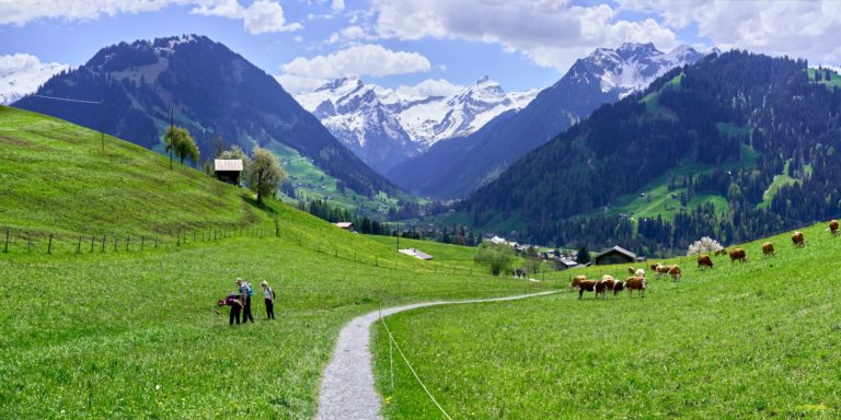
Description: A scenic descent through high meadows with mountain huts and farm animals along the way. Ideal for a late afternoon hike or sunset descent. Bort also features a great playground and restaurant.
🧳 Hiking Tips for Grindelwald
🌦️ Weather: Alpine weather is unpredictable — always check conditions before heading out.
🥾 Footwear: Lightweight hiking boots or sturdy trail shoes recommended.
🚠 Cable Cars: Take advantage of the First, Männlichen, and Pfingstegg lifts to gain elevation.
🗺️ Maps: Pick up a Grindelwald trail map or use apps like SchweizMobil.
💧 Essentials: Bring water, snacks, and sun protection — some trails are very exposed.
🧭 Navigation: Most trails are well-marked, but GPS apps and paper maps are always handy in poor visibility.
🧀 Food & Refuges: Many routes pass mountain huts with local cheese and hearty Swiss cuisine — check opening hours in advance.
From dramatic ridgelines above turquoise lakes to glacier-fed streams below towering cliffs, Grindelwald’s hiking scene is second to none. Whether you’re new to the Alps or a seasoned alpine explorer, these trails offer something special: a chance to disconnect, recharge, and witness the raw beauty of Switzerland’s iconic mountains.
Take your time, bring your camera, and let Grindelwald’s majestic terrain lead the way.